WALKS
Walk 1: A circular walk around Headcorn Village
Headcorn is lucky in having many footpaths around the Village. Here is a suggestion for a walk that starts and ends in the Village. It's around 4km, although I didn't measure it precisely. There is a map of the walk here:


Starting point in Lenham Road
The little bridge
The path crosses through crop fields
The access from Maidstone Road

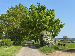
The path KH584
Walk 2: From Headcorn Village to Headcorn Aerodrome

You can check your route or make your own using the KCC Footpaths map on the link here

This walk takes you from Headcorn Station to Headcorn Aerodrome. It takes you across fields to Waterman Quarter, across the A274 to Shenley Road and the Aerodrome. There are bridges and stiles to cross. Click on the description file below to view the detail.
You can view/ download a pdf file by clicking on this image
Start at the entrance to the Lenham Road Fields. Cross three fields following footpath KH587. Right at the end of this you can see this little bridge (you could choose to continue on KH336, but I took a left onto KH342A.
Continue ahead, crossing the Ulcombe Road when you reach it. This becomes footpath KH342. A little further ahead you will see a disused barn on your right. Slightly further on on your right you will see a small wooded area with bluebells (in April). As you continue, take a sharp left onto footpath KH341.
Stay on this footpath, across fields, when it becomes footpath KH584. Cross Tattlebury Lane and continue towards the A274. Once there, turn left to return to the Village.
Walk 3: Circular route to Kelsham Farm and School House Farm
Something a little different. A longer walk of around 2.5 hours but all flat and taking in some interesting, quieter paths.


You can view/ download a pdf file by clicking on this image
A map of the route


The route

A map of the route
Would you like someone to walk with? Take a look at the Clubs page, there are two groups you could join:
Scroll down to NEW Brissenden Vineyard Walk
No6

Walk 4: Circular Walk South
A longer walk of about 3 hours (though there is a very short option). Takes you to Little Brookwood, Bubhurst Farm and Waterman Quarter.


You can view/ download a pdf file by clicking on this image
A map of the route

Walk 5: Village Circular Walk
Using new pathways near the Village hall, why not take this circular route around the village, taking in the open spaces. It is predominantly flat but does include areas walking on grass (at Hoggs Bridge Green) and bark (near the Village Hall).

Walk 6: Walk to Brissenden Vineyard
This is a new walk which takes you from the Village centre to Brissenden Vineyard. It's about two miles and is mostly off the road or on quiet lanes (depending on your own chosen route). It should take around 1 hour and 10 minutes.
NEW!
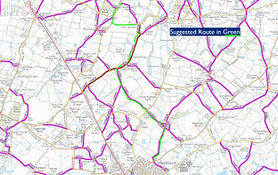
You can view/ download a pdf file by clicking on this image
The route, in green